
Hoxsie has been on an extended hiatus, and comes roaring back with . . . almost nothing. There’s not a huge amount to say about this bicentennial tablet in the first place, and we were unable to find its fate.
Bronze tablet, 11 x 23 inches, set in granite block in sidewalk, near curb, similar to No. 7, [southwest] corner of South Pearl and Arch streets: Inscription: “Beaver Kill — Ancient Water Course flowing to the River now Arched Over. Buttermilk Falls in the Ravine to the West.”
The Argus listed this as one of the tablets that remained undisturbed in 1914. But there is no evidence of it now, and we’ve been unable to turn up any evidence of when it may have disappeared. If it was truly set into the curb as described, it could have been torn up in any number of street or sidewalk projects. And the ancient water course that it commemorated was, of course, long gone even by 1914.
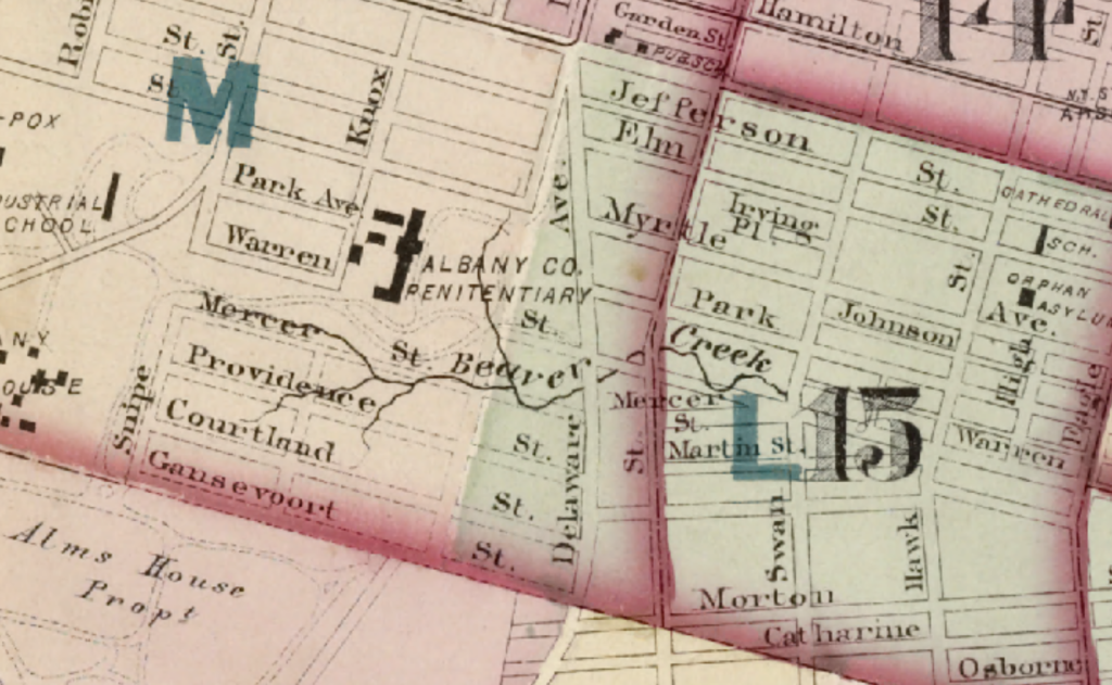
The Beaver Kill (or Beaverkill; let’s not be pedantic) was the southernmost of the three streams that ran through Beverwijck, and probably the most majestic of the three, running from somewhere along Western Avenue through what is now Lincoln Park, where it descended over Buttermilk Falls through brickmaking yards and a shantytown called Martinville. The ravine remains, but the kill was piped underground even before the park was developed, and has recently been part of the “Beaver Creek Clean River Project” meant to address combined sewer overflows into the Hudson River.
An 1890 article in the Albany Morning Express, giving the history of Albany’s sewers, provided a detailed description of the course of the Beaver kill, which was already converted into a sewer for significant stretches:
“As outlined now within city bounds, the course of Beaver creek is eastward between Myrtle and Madison avenues to Lexington Avenue, then across Lexington to Myrtle, and thence to Knox street; a northward curve takes it to Morris street, where it bends back through the lines of Lark street (continued) and winds its devious course southeastward to a point far south of Warren street, just west of Delaware avenue. With few exceptions, the creek’s channel up to this point is an open one. From this point to a point in Warren street east of Dove a large stone archway until recently served as a creek channel; thence again as an unfettered stream the creek rushed on and plunged over Buttermilk Falls just west of Swan street and into the Martinville valley. From here an 8×8 foot stone archway which followed the northwest curve of the stream east of Swan street to Park avenue and Warren street. Down Warren the stone archway was continued to Grand street as a 8×8 ft., 10 ft.x4 ft. 7 inch, and 11 ft.x5 feet 4 inch sewer, which cut across lots and entered the river under Arch street.
“The new Warren street sewer, but just completed, connects with the Myrtle avenue 8 ft. circular brick and cement sewer at Lark street (continued), and crossing over Lark to Warren, is built in a straight line down the latter street to Grand, thus cutting off and abandoning the old tortuous Beaver creek line down through the picturesque Martinville as above described. From Grand street to the river the old sewerways are used.
“The Myrtle avenue connection above being referred to is the receiving basin of the Washington park lake overflow, and is but the branch of the old Beaver creek now transformed into a 5 ft. 6 inx5 ft. round brick and cement sewer, passing along the south shore of the lake and up through Elberon place to Quail street, where it receives the flow of a 4 ft. circular brick and cement sewer from the north, a 15 in. vitrified pipe sewer from the south, and an old stone arch 4 ftx5 ft. sewer from the west. The park lake outlet reaches this sewer line on Lexington avenue just south of Madison avenue.
“Upper or western Madison avenue drains in at this point through an 18 inch brick and stone sewer, while the short westward slope of this same thoroughfare from Lark street also joins near this point.
“Into this Lexington avenue cross sewer the westward slopes of Yates and Morris streets are drained through 18 in. brick and cement sewers from Lark street.
“The sewage and drainage from Delaware avenue south of Madison avenue flows into Beaver creek sewer through an 18-inch brick and stone sewer.”
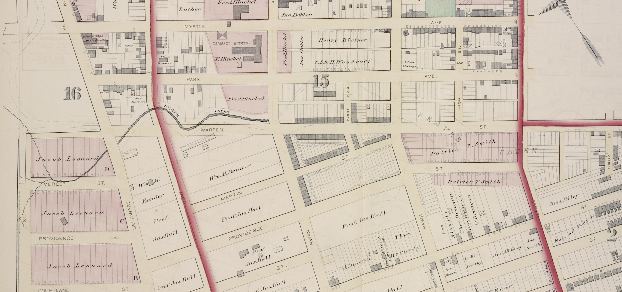
As this illustration from the 1876 Hopkins map shows, the Beaver Kill went underground at Swan Street even then, but the map also shows some of the rest of the original course of the kill, at least to Phillip street:
Bill Kennedy, before he was the famous novelist William Kennedy, wrote a 1964 article in the Times-Union regarding some legends of the Beaverkill, including the following:
“Back in the early 1890s, so the story goes, an imaginative landlord named Lackey Doherty advertised a house with running water for rent on Swan Street. What made this unusual was that the house was not a very grand house and the Swan Street neighborhood was not a very grand neighborhood, but was Martinville, a notorious Irish shanty town. So it was with great interest that people trooped over to the Doherty place to see the running water. True to his word, Lackey took the visitors downstairs and showed them the water – the Beaverkill Creek running underneath the house. And there was more than water in the creek. There were geese.”
Kennedy quoted a resident saying that Martinville was “a lot of wild land and 25 or 30 houses,” and another who said that it was “a tough spot where goats used to graze on garbage piles on the side of the hill.” At the time, the Beaverkill crossed Delaware Avenue underneath a wooden bridge, then went over Buttermilk Falls.
“Its ravine was quarried for clay and brickyards sprang up in the area – Bender’s on Delaware Avenue (where school 24 is now), and Moore’s and Stannix’s and Babcock’s and Smith’s on Morton Street overlooking the creek, which by this time had become filthy and swampy. The bottom of this hollow was where Martinville grew, even in its best days not much of a place. In 1880 the medical society voted it a ‘dangerous nuisance’ and in 1883 the Board of Health condemned it.”
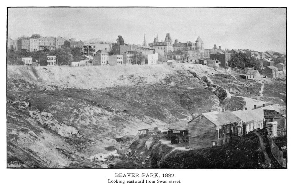
Despite a commission’s conclusion that a park on the site would be “substantially useless” and not good for summer as it had no breezes or natural attractions, with State Legislative approval all houses in the hollow and the north side of Morton Street were torn down or moved and in 1894 construction began on Beaver Park, which later became Beaver Park.
When the Empire State Plaza was under construction, there were still some structures on the northern border of the park, and “upper income private apartment housing is presently under construction there,” Kennedy reported in 1964, but the other structures were being torn down.
As ever, we can dream that this tablet is still out there somewhere, but we’ve found no reliable sightings since 1914.
As an aside, there is just so much history around the Beaverkill, Beaver Park and Lincoln Park, that it was hard to know where to begin and where to end. A reader reminded us that this was the site of a pivotal early conflict where the newly arrived Dutch took sides with Mahicans in a battle against Mohawks in 1626, setting up a dangerous situation that caused an evacuation of many of the Europeans to Manhattan until diplomacy prevailed. Paula Lemire wrote all about that here. And Friends of Albany History expanded on it here.
1 thoughts on “Albany Bicentennial Tablet No. 23 – Beaver Kill”