
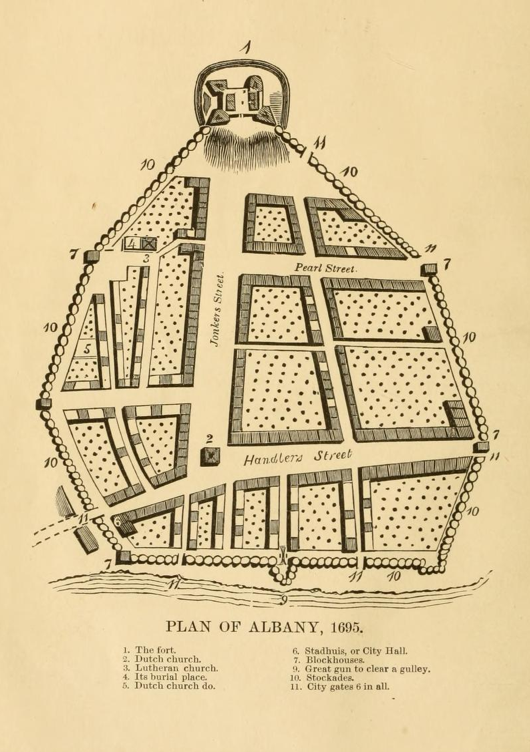
One last map because it’s too great to resist. From Joel Munsell’s “Men and Things in Albany Two Centuries Ago,” this magnificent diagram depicts Albany in 1695. The original was made by Rev. John Miller, chaplain of the English grenadiers. At the top of the map (which is the westernmost point – maps of Albany have long defied the customary north-at-the-top orientation) is Fort Frederick, at the top of what is now State Street, below the modern Capitol. The circles marked ’10’ are stockades, made from broad logs generally 13′ high; ‘7’ marks the blockhouses and ’11’ marks the “City gates 6 in all.”
The streets are familiar to anyone who knows downtown Albany. Pearl Street’s name is unchanged; Jonkers is now State, and Handlers, the mercantile center, became Broadway. Gone from the center of the intersection is the original Dutch church; Akum Norder gives a delightful account of how it was replaced on the same spot without disrupting services.
By 1695 there was a Lutheran Church (number ‘3’), somewhat tucked away from the main street. Its burial place was right beside it, whereas the Dutch burial ground was at the edge of the city.
The “Stadhuis, or City Hall,” was down at the end of Handlers Street, along what is now the Plaza in front of the SUNY Administration Building.
Down at the river’s edge, Number 9, a “Great gun to clear a gulley.” Presumably this gun had a command of the river.
