-
Staats House
•
Joel Munsell in his “Men And Things in Albany Two Centuries Ago” (1876) described the now-long-gone historic house at the corner of South Pearl and State: “What is now South Pearl street was only a narrow irregular lane leading to the Lutheran church and its burial ground adjoining on the south, bounded by the…
-
Albany, 1695
•
One last map because it’s too great to resist. From Joel Munsell’s “Men and Things in Albany Two Centuries Ago,” this magnificent diagram depicts Albany in 1695. The original was made by Rev. John Miller, chaplain of the English grenadiers. At the top of the map (which is the westernmost point – maps of…
-
Numbering streets: Ur doin it wrong
•
Visitors to modern Troy, New York are frequently perplexed by the one-way streets, and by the fact that First through Fourth are streets, Fifth, Sixth and Eighth are avenues, and Seventh has mostly disappeared. Fine. That’s nothing compared to the confusion of olden Troy, say 1895, when Fourth Street ran between Sixth and Eighth.…
-
The Lumber District, then and now
•
Another view of Albany’s Lumber District, once one of the busiest in the world, to show what was there in 1895 and what is there today. At the time, the combination of Erie Canal and rail access made this an extremely important lumber handling center, and of course many other industries were settled in…
-
Albany’s Lumber District, 1857
•
Lots of Albany streets look pretty much look the same as they have for centuries. Not the Lumber District. A time traveling lumber worker from 1857, when this map was made, would be amazed to find the streets, canals, quays, and warehouses all gone, with hardly a sign remaining of their ever having been…
-
Schenectady, 1906
•
Again, unfortunately, the scan of Robson & Adee’s 1906 map of Schenectady and environs loses some of the image in the fold, but still here is a nice view of the city that lit and hauled the world. The streets are largely unchanged. The General Electric Works, while greatly reduced, still sits on the…
-
Map Fortnight: Scotia, 1906
•
From Robson & Adee’s 1906 map of “Schenectady and Environs,” another early 20th century view of the village of Scotia, New York, my somewhat idyllic hometown. The fold in the scan cut out a little section.
-
Map Fortnight: Collins Park, Scotia, 1905
•
Hoxsie’s still busy, so more pretty pictures. This is a lovely map of the area that would become Collins Park in Scotia. This was 1905, so Washington Avenue was still the route of the trolley of the Schenectady Railway and the Fulton, Johnstown & Gloversville (though this map says, “FJ&A” instead of the more…
Recent Posts
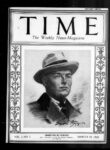
- Polo Player Nabbed As Game Violator
- Amsterdam Heiress: Prisoner of the Nazis

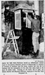
- The Stockade’s Antique Phone Booth