Continuing our series on the stories behind the 1886 bicentennial tablets commemorating important places in Albany, we have our first marker laid in a sidewalk, telling us of the nearby location of Fort Frederick.
Tablet No. 11 – Fort Frederick
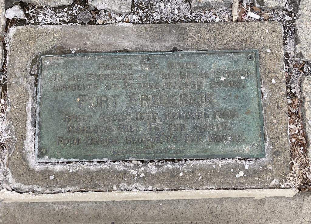
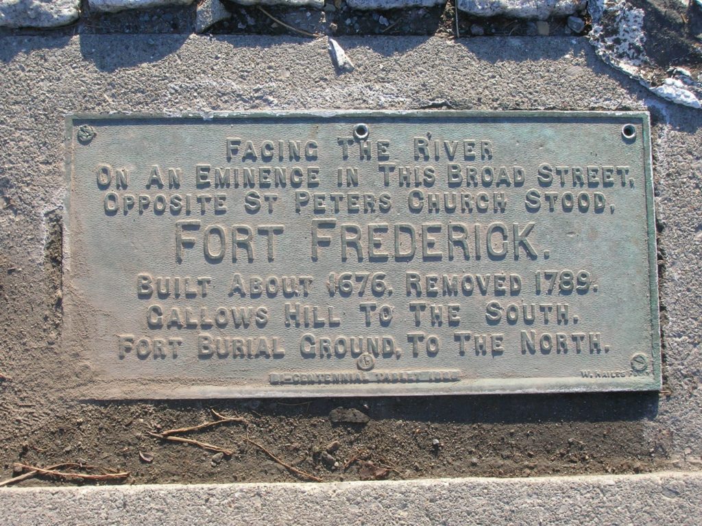
Located head of State street, in sidewalk, near the curb on lower edge of Capitol Park—Bronze tablet, 11×23 inches, set in granite block similar to No. 7. Inscription :
“Facing the River on an Eminence in this Broad street opposite St. Peter’s Church Stood Fort Frederick. Built about 1676—Removed 1789. Gallows Hill to the South Fort Burial Ground to the North.”
The very first fort in this area, Fort Nassau, was built by and for the Dutch West India Company’s trading operations, in 1614 or 1615. It was built on what was then an island, now part of the Port of Albany and firmly mainland, and it was built on land that flooded every spring, making it less than ideal as a fort. It was abandoned in 1618.
It was 1624 before another fort was built, at a somewhat more advantageous, but by no means flood-free, location to the north on what is now Broadway – this is the fort known as Fort Orange (there’s a bicentennial tablet there, to be sure). According to the New Netherland Institute, Fort Orange had already fallen into disrepair when the English took over the Dutch colony in 1664, and they say that in 1676, the English government constructed a new fort high enough up the hill that it didn’t turn into a swimming pool several times a year, and it commanded the trading path to the west. This was Fort Albany.
Forts Albany
It is very hard to nail down solid information on the timelines of construction, demolition, and naming of the forts that followed Fort Orange, but we will try. First, we have to ignore a number of normally reliable sources that get the names of the forts wrong and misjudge their timeline.
Cuyler Reynolds, in his “Albany Chronicles,” says that a fort (he names it Fort Frederick) was constructed at the head of Yonkers street (later State Street) in 1676. He said that came about after Governor Andros inspected Fort Orange in March 1676 and found it in “deplorable condition.” But at that time there was no Fort Orange: it was already called Fort Albany.
We’ll rely on local researcher Cliff Lamere, who found the same problems we did in trying to explain the story of the fort. Mr. Lamere came to the conclusion that there were three forts in this location, and only the last of these was called Fort Frederick. (Mr. Lamere’s work on this is on this webpage.)
First he notes that Fort Orange was renamed Fort Albany by the English in 1664. During that brief return of Dutch rule in 1673, it was renamed Fort Nassau, only to have its name reverted to Fort Albany when the English regained control. That old fort was abandoned in 1676, and Lamere reports that there were still some visible remains in 1812.
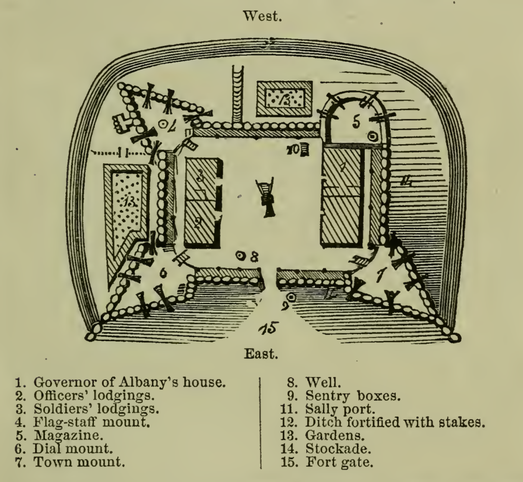
In 1676, the second Fort Albany was constructed of wood on the higher ground of Yonkers Street. This would appear to be the structure depicted on a plan related by British chaplain Rev. John Miller in 1695 (shown below): a palisaded fort surrounded by a “ditch fortified with stakes.” It contained a house for the governor of New York, lodging for officers and soldiers (totaling 150 men in 1689), and 20 or 21 cannons. (This plan has been published any number of times with the name Fort Frederick assigned to it, but as it predates the cornerstone of that fort, and the birth of its namesake, by several years, that is clearly in error.)
In 1702, Governor Cornbury wrote that “The fort is in a miserable condition . . . The stockades are almost all rotten. There is but 23 guns in the fort, most of them unserviceable.” The War of Spanish Succession, known around these parts as Queen Anne’s War, was under way, and Cornbury was on a campaign to shore up an alliance with the Iroquois and to rebuild New York’s frontier forts to protect colonists and their allies. According to a 2003 history by William Glidden (posted at the Division of Military and Naval Affairs), Cornbury undertook to replace the stockaded fort with a stone fort. (We have not found reference to how the new construction and the old fort co-existed.)

Who was Frederick?
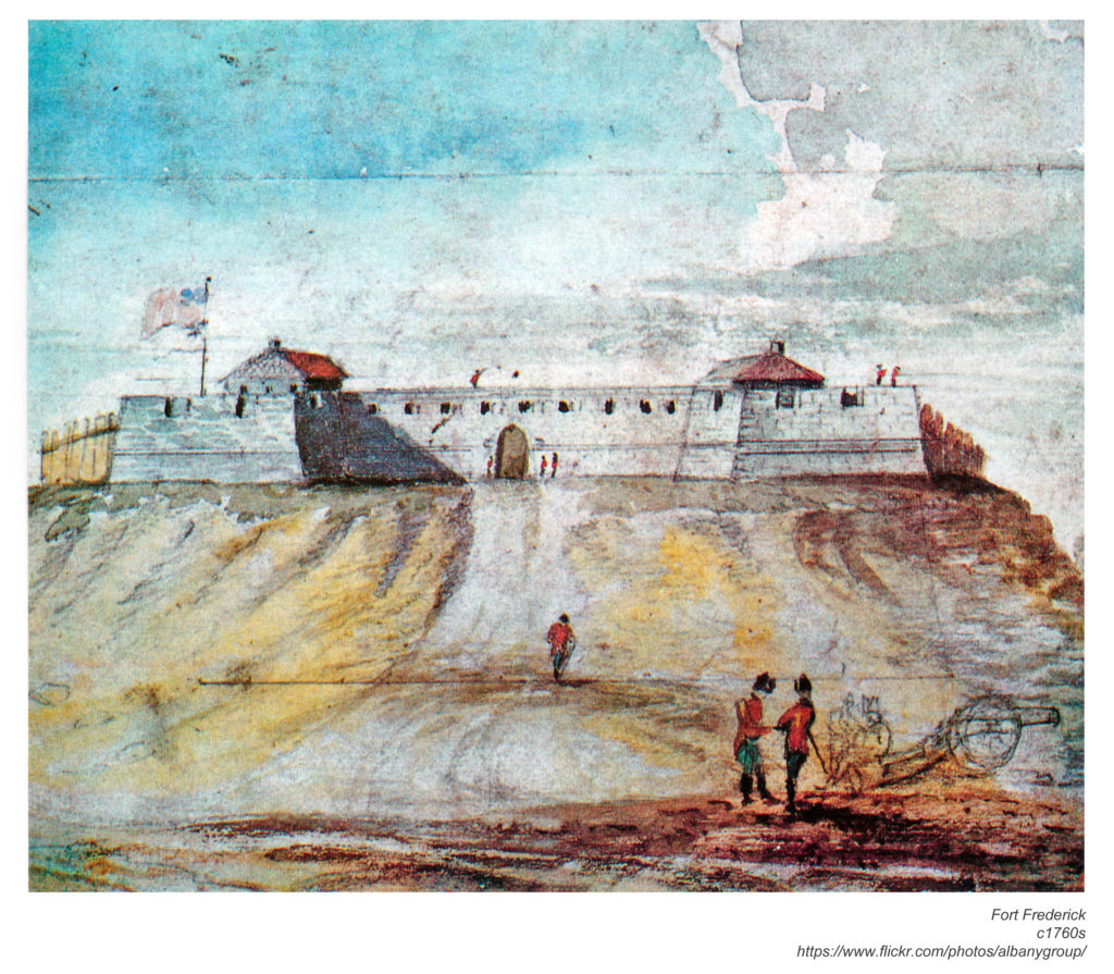
The cornerstone for this third version of Fort Albany was laid August 15, 1702; it was planned to have stone walls five feet high. Cornbury was calling the new fort “Fort Anne” for his cousin, Queen Anne. The formal name of the massive stone fort remained Fort Albany, however. A report to the Board of Trade on June 2, 1738 indicated that the stone fort, which could hold 300 soldiers and was armed with eight or ten large cannon, was finally complete (after a mere 36 years) and named “Fort Frederick,” in honor of Frederick Louis, the eldest son of King George II. This seems to be the earliest that the fort could be considered to be Fort Frederick.
If Frederick’s name doesn’t ring any particular bells, it’s not too surprising; the Prince of Wales was known as something of a wastrel, a cricket player, and a patron of the arts. For those affronts to royal obligations, and others, Frederick had just been banished from the King’s court when this fort was named for him. He had also just fathered a child named George William Frederick – who would become King George III.
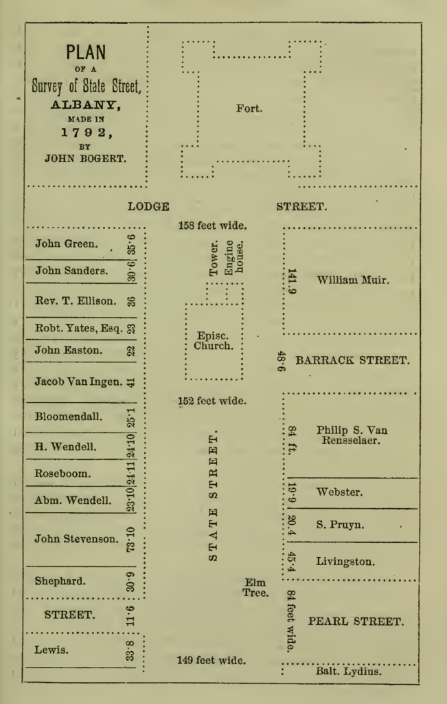
Munsell said “The position of the Fort is believed to be very accurately given. The northeast bastion occupied the ground where the Episcopal Church [Saint Peter’s] now stands. Its foundations were as high as the top of that church. it was the fourth place selected for a fort, and was first, it appears, inclosed by stockades merely . . . for several years the fort supplied material for buildings and the public sewers.” Munsell reports that the fort began to be demolished immediately after the revolution; Cuyler Reynolds put it some years later.
The location of this fort was well described in the Albany Evening Journal in 1859:
“… on a line with the upper side of Lodge street, the battlements of Fort Frederick stood upon a lofty eminence overlooking the city, and stretching nearly across the street, the road to Schenectady winding around its southern angles. The city was surrounded by a wooden barrier, consisting of stockades constructed of pine logs one foot in diameter, and thirteen feet long, inserted into the ground by being sharpened at one end, and fastened together near the top by dowels, or wooden pins. Blockhouses were erected at the gates on the north, west, and south sides, which were defended by cannon. The stockade at this time [1715] extended no further south than Hudson street, and was limited on the north by Steuben street; the Fort formed the western barrier, and the river the eastern. Within these narrow limits there was a population of about 3,000, and a garrison of 300 more.”
The quality of protection offered by the fort seems to have often been in question, to say the least. Common Council records from 1708 indicate a letter from Col. Peter Schuyler recommended immediate repair of the blockhouses, batteries and great guns, “wh[ich] he Recommended might be forthwith Repaird Since we are dayly in Expectation of ye Enemy.” The Council expressed concerns that they had just seen to the fitting of the fort the previous winter, “& are apt to believe [that] if ye Militia officers had taken good Care & not Suffered their People to break burn & distroy what ye Common Councill caused at so great Charge & Expence of ye Citty to be made, there had been no need to be at this difficulty now.” It was apparent that some of the great guns had been “spickd” (meaning spiked) “willfully by disorderly & wicked persons [that] Commit all manner of Insolencies upon ye watch by reason of ye officers neglect in not appearing upon ye gaurd.”
Essentially, the militia, residents, or both were committing acts of vandalism that ruined the fort’s usefulness. Nevertheless, the Council resolved to pay again to get the Fort in shape. [Annals of Albany, Vol. 5]
The Albany Argus in 1903 quoted local historian John Lossing, who had written about the ineffectiveness of the fort (Lossing was one of a handful who argued that the fort had been named “Williamstadt,” a Dutch name that applied to the city for only a year):
When, toward the middle of the last century, the province was menaced by the French and Indians, a strong quadrangular fort, built of stone, was erected upon the site of that of Williamstadt. Within the heavy walls, which had strong bastions at the four corners, was a stone building for the officers and soldiers. It was named Fort Frederick, but its situation was so insecure, owing to higher hills in the rear, from which an enemy might attack it, it was not regarded as of much value by Abercrombie and others during the campaigns of the Seven Years’ war.
The Argus also quoted Swedish naturalist Peter Kalm, who visited Albany in 1749 (and was none too happy about it): “The fort lies higher than any other building, on a high steep hill on the west side of the town. It is a great building of stone, surrounded with high and thick walls. Its situation is very bad, as it can only serve to keep off plundering parties, without being able to sustain a siege.”
A fort no more
If no one quite agrees when Fort Frederick was constructed, it’s worth noting that they don’t agree when it was demolished either. Cuyler Reynolds reported that it was demolished in both the spring and fall of 1784, but in the same volume said it was demolished in the spring of 1785, when the city authorized the demolition and “using of the stone for public improvements, and the clergy of various churches to be allowed material of the walls with which to build their churches.” He also reported that in 1786, the city employed workers to remove the earthen embankments around the fort. Several reports of the celebration of the new Constitution in 1789 indicate that it took place to the west of Fort Frederick, writing as if the fort (or at least part of it) still stood. The Albany Argus, in its 1899 celebration of the North Dutch Church’s 100th anniversary, said, “The old church has as its sturdy foundations stone from Fort Frederick.”
Of course, this being Albany, from time to time evidence of the fort might re-emerge when construction was undertaken. And this being Albany, from time to time such evidence would also completely disappear. The Argus in 1897 reported that noted local lawyer/author Lucian Brock Proctor had the good fortune to come upon such evidence:
“Mr. L.B. Proctor, secretary of the State Bar association, is considerable of a collector of antiques. Recently, as he came down State street he stopped to watch the men at work digging for the foundation for the new Albany Insurance Company’s building, which is to adjoin the county building on the west. He noticed that the men struck a well-preserved timber which still contained some of its bark. This was ten feet below the surface, and Mr. Proctor concluded from its condition and position and from the fact that the building, which was but recently torn down, had stood for more than 100 years, that it was a part of the bastion of Fort Frederick. If such is the case the timber has rested in the ground for more than 200 years, and its preservation is remarkable. Mr. Proctor had his “find” cut into small pieces, which he distributed among his friends.”
Yep. Now, it’s possible the Albany Institute or or some other local repository was considered as one of Proctor’s friends and has some bit of wood supposed to have been from Fort Frederick. but it’s also possible they were used as toothpicks.
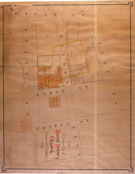
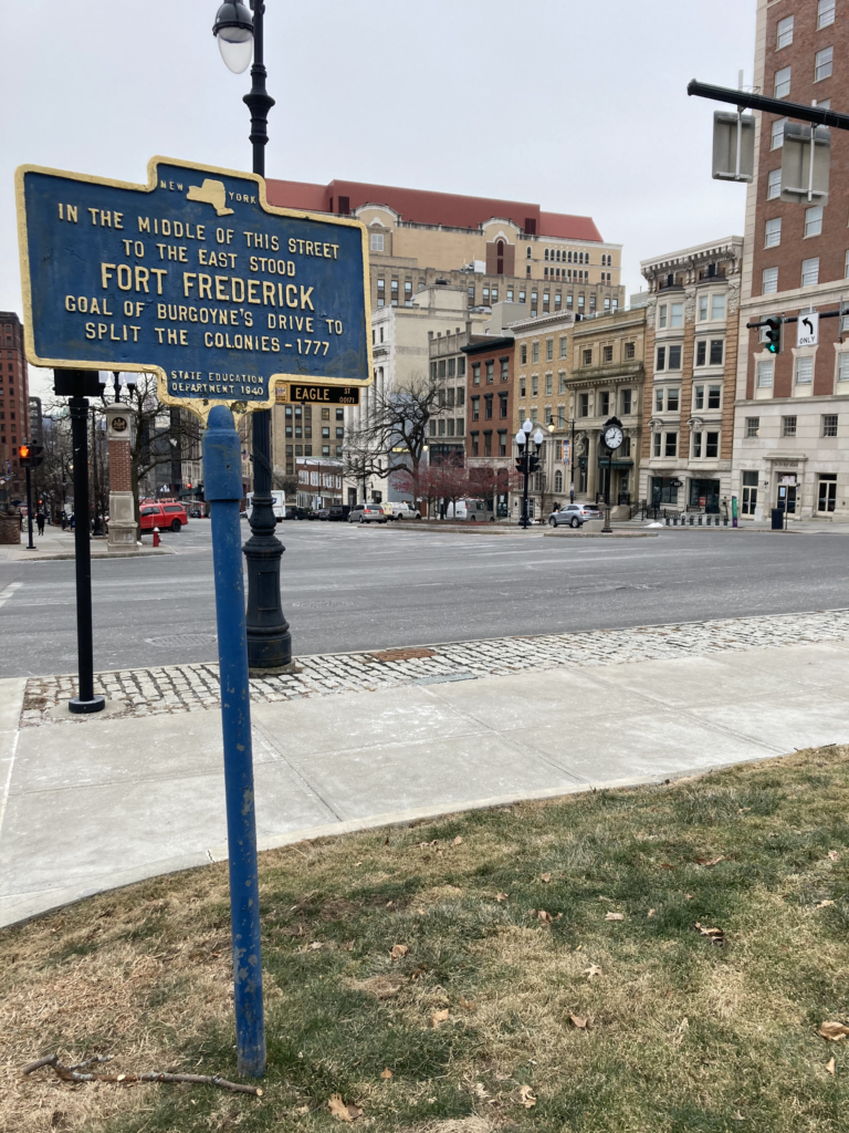
As for its location, this marker, placed in sidewalk in front of the Capitol, is way too far up the hill to represent the location of Fort Frederick. Above is a map drawn by city engineer Horace Andrews in 1899 (located by Cliff Lamere), showing the fort as extending into most of State Street, and extending northward on the lot now occupied by St. Peter’s Church; in a westward direction, it didn’t come quite halfway to Eagle Street.

Leave a Reply