
The last several tablets placed by the Albany Bi-centennial Committee in 1886 were simple commemorations of several streets – and not always major ones. Some still exist, but this one has disappeared.
Tablet No. 32—Washington Avenue
Bronze tablet, 7×16 inches, placed on corner of Capitol building. Inscription: “Washington Avenue, formerly King, then Lion Street.”
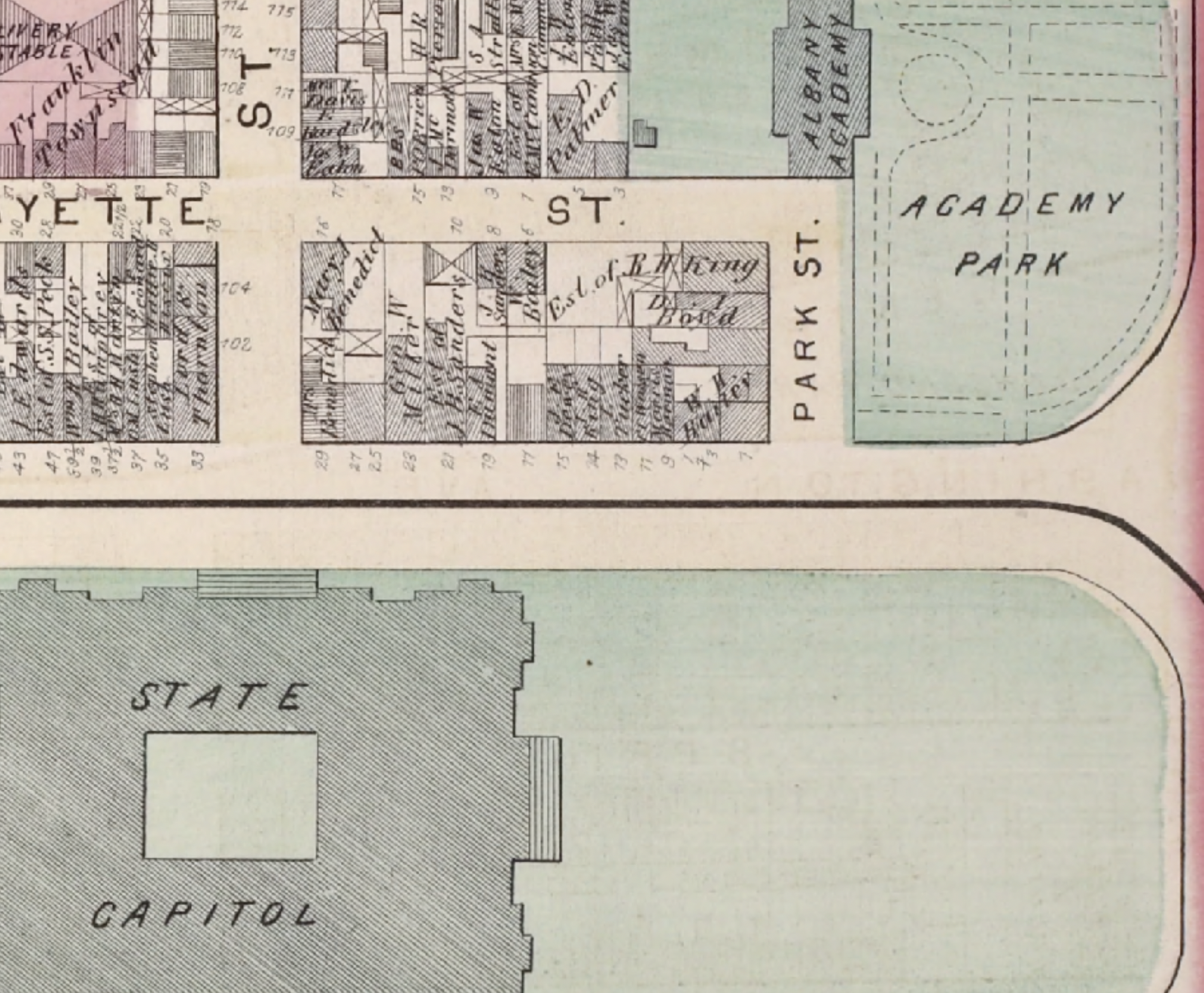
The Argus wrote in 1914 that this had been placed on the northwest corner of Washington avenue and Park place, instead of on the Capitol. Presuming they meant Park Street, well, we’ve got a problem. Park Street used to run from Washington Avenue up to the Academy Building (on the south side of the east Capitol park, it still runs as a stub alongside the Telephone Building). The building on that corner was one owned, in 1886 anyway, by Dr. W.H. Bailey. The building the tablet was likely demolished when the state created Lafayette Park, a process that began in 1908 but apparently dragged on for many years.
Nearly a year after originally posting this entry, we found a Knickerbocker Press article from May 26, 1928, headlined “Historic Tablet is Missing From Building Being Razed.” It says that the “bronze tablet owned by the city and which for many years has been on the building at the corner of Washington avenue and Park place was missing yesterday. Investigation will be made to determine if it was stolen or was removed to a place of safety owing to the razing of the building, one of a group being removed to make room for a park.” Cuyler Reynolds, city historian, said that the tablet had been in place the Thursday before, and that it had been proposed to move the tablet to City Hall. But apparently that didn’t happen.
Howell’s “Bi-centennial History of the County of Albany, 1609-1886,” indicates that in 1804 the Common Council ordered “parts of State, Lion (now Washington Avenue) and Washington (now South Pearl), which remained unpaved and great out of repair, should be immediately paved by the owners and occupants…”
The New York State Museum confirms Howell’s accounting of the names. Pearl Street was just what is now North Pearl Street until 1814 or 1815, when that became North Pearl and the southern part, which had been called Washington Street, “reputedly because George Washington walked along it to Schuyler Mansion in 1783,” became South Pearl Street. Prior to Washington, it was sometimes called Cow Street, as it led to the pastures that we now know as The Pastures.
Source: Albany Institute of History and Art
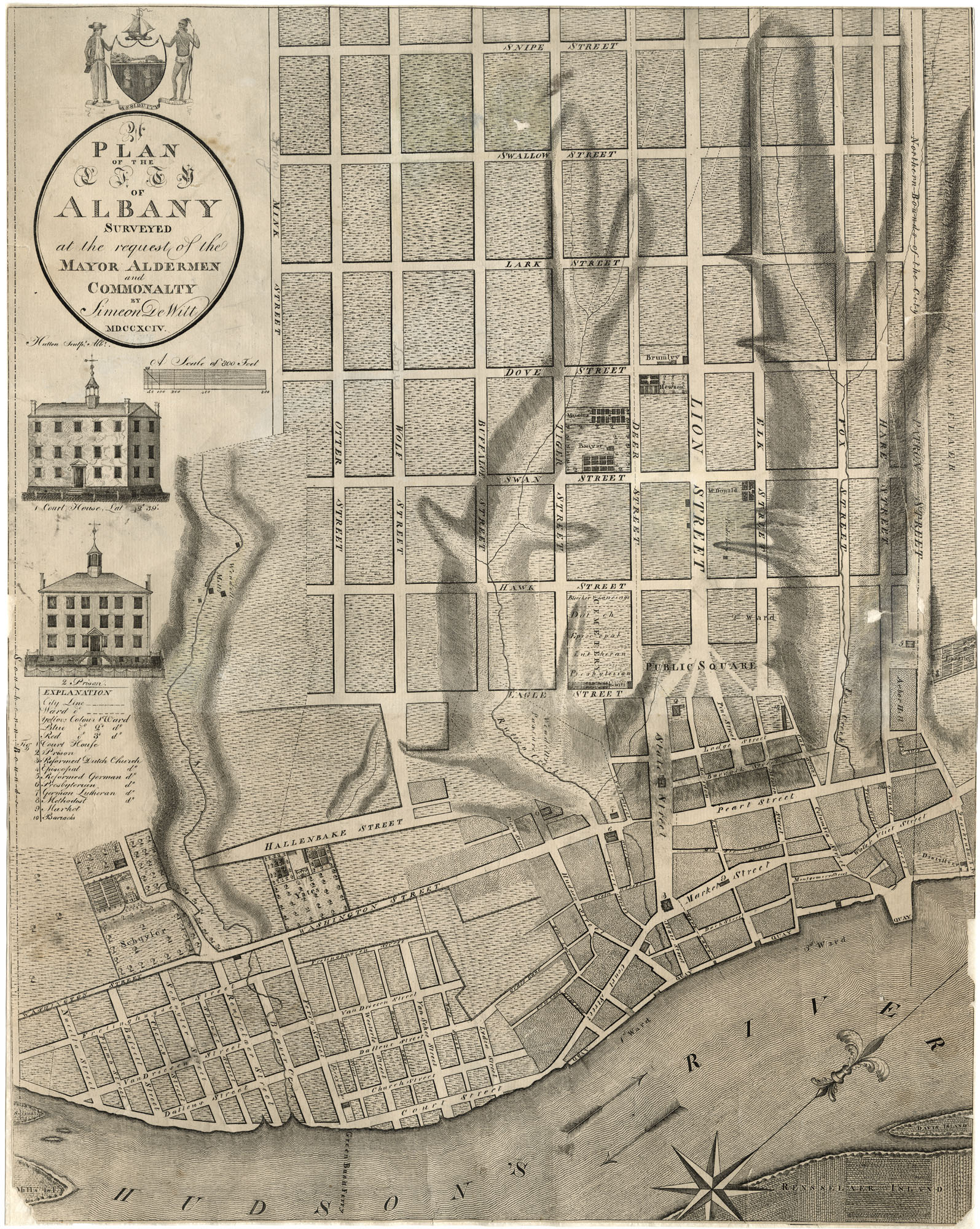
The DeWitt map of 1794, above shows Albany laid out on a grid west of Eagle Street, and the east-west streets on that grid all bore animal names – nearly all of which have been replaced in that time. The north-south streets bore bird names, which have somehow survived the years better. Running south the north, the streets were: Mink, Otter, Wolf, Buffaloe [sic], Tiger, Deer, Lion, Elk, Fox, and Hare. The northernmost of these streets, the boundary of the city, was Patron [sic] Street; decide for yourself whether the Patroon was an animal. Lion was then, as now (as Washington Avenue) the widest of those.
So, how do we know those streets today? Mink was probably what became Myrtle, and Otter is now Elm (which doesn’t continue unbroken above Delaware). Wolf became Lydius Street (for Dominie Johannes Lydius), which later became Madison Avenue. Buffalo is Hudson, Tiger is Lancaster, and Deer is State Street. North of Lion, we have Elk Street, which is somehow still Elk Street. Fox Street became Canal and then Sheridan Avenue. Hare became Orange Street. Patroon Street (misspelled by DeWitt) is present-day Clinton Avenue, having gained that name in 1815 when the city line was extended north.
Lion (or Lyon) Street ran west from the public square (essentially East Capitol Park today, adjacent to the old fort along the King’s Highway, and was for a time called King’s Street – it was still called that in 1778, when lots along it were recorded as being sold, but by the time of Simeon DeWitt’s map in 1794, the name had been changed to Lion, no longer honoring a monarch but instead honoring a symbol of monarchy. (Baby steps.) It might be reasonable to guess that its name was changed to Washington in 1815, when several other street names (including the previous Washington Street) were changed.
But the animal and bird streets weren’t the original street names, either. In 1762, a layout of the city that divided up new lots on Gallows Hill showed Patroon street (Clinton Avenue) as the north boundary of the city, and the parallel streets running south of that were Wall, Howe, Queen, King, Prince, Prideaux, Quiter, Wolfe, and Pitt. It was at the intersection of Pitt with Duke (Elm with Eagle) that the lots of Gallows Hill were laid out; this is now the site of the All Saints Cathedral.
Howell wrote:
“Albany streets have had their names changed frequently, and, it must be admitted, not always for the better. In 1790 the names of several were changed, among them the following: Duke to Eagle, Boscawen to Swan, Warren to Dove, Johnson to Lark, Gage to Swallow, now Knox; Schenectady to Snipe, now Lexington avenue; Schoharie to Duck, now Robin. The next parallel street was called Pigeon, now Perry; the next Turkey, now Quail; the next Sparrow, now Ontario. Wall street was changed to Hare, now Orange; Howe to Fox, now Canal; King to Lion, and afterwards to Washington street, now Washington avenue; Prince, west of Eagle, to Deer, now State; Prideaux to Tiger, now Lancaster; Quiter, so called to perpetuate the Indian name of Peter Schuyler, was changed to Buffalo, now Hudson avenue; Wolfe, named after the hero of Quebec, was changed to Wolf, afterwards to Lydius, now Madison avenue; Pitt to Otter, then to Westerlo, now Elm; Monckton to Mink, then to West Ferry, now Myrtle avenue.”
That was 1790. Then in 1805, with extension and improvement of several streets, there were more changes: Kilby became Hamilton (from South Pearl to the river); Bone Lane became Division Street; Cow Lane became Liberty; Nail became Howard; Barrack became Chapel.
After 1805, Howell recorded a number of other changes that have helped keep local history buffs scratching their heads. Capitol became Park; Mark Lane became Exchange; Middle Lane became James; Frelinghuysen became Franklin; Dock became Dean; Bass Lane became Bleecker; Store Lane became Norton; Sand became Lafayette; Van Driessen became Green; South became Gansevoort; High became Ten Broeck; Macomb became Broad; Embargo Alley became Dennison; Whitehall road became Whitehall avenue became Second Avenue; Van Vechten became Third Avenue; Delaware Turnpike became Delaware avenue; Elizabeth became Second; John became Third; Van Schaick became Monroe; Lumber became Livingston, and Perry became Lake Avenue.