
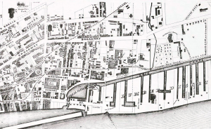
Lots of Albany streets look pretty much look the same as they have for centuries. Not the Lumber District. A time traveling lumber worker from 1857, when this map was made, would be amazed to find the streets, canals, quays, and warehouses all gone, with hardly a sign remaining of their ever having been there. The Albany Basin, seen in the lower left, is completely filled in. The Canal Basin, as well. Other than a historic marker, there’s no evidence that the most important water highway in our country’s history, the Erie Canal, was ever even there. Coming from a time when thousands were employed here, he’d be stunned to find the streets streets with names he’d recognize to be largely empty. There are still freight trains running up what is marked as the “Canada Rail Road.” Montgomery Street is broken up and stubbed; Quay Street (closest to the river on the left) remains primarily as a highway access road, and the rest of it is underneath Interstate 787. The waterfront, from the boat launch to the east of Ferry Street downriver to the Corning Preserve, is now recreational, rather than the booming, working waterfront it was back then.